
>Home page> |
Introduction |
Geometrical facts |
Key places |
Speculations
 An Essex mystery
Why should three pubs in Essex all called The Compasses be in a straight line 10
miles long? The 4th pub called The Compasses creates a circle and points to an
ancient centre of Templar activity. Other strange coincidences.
Geomancy, Masons, Templars and the Peasants revolt (1381) could all be
linked.
Introduction
The facts of the geometry are plain for all to see and are described in part 1. It is difficult
to dispute the map references, and difficult to avoid being impressed by the co-incidences. Is
the geometry a fluke or deliberately organised? If organised, then who by and what was the
significance? It is impossible to dismiss the geometry and close the case without looking
into possible significances. The obvious ones are masonic and/or Templar, and it is
along those lines that I am seeking out evidence going back 800 years, which for a suppressed
and secretive organisation is going to be rather conjectural. However the
firmest facts are those on the map. The geometry points to two places on the map that today
show no signs of any significance whatsoever. In the event of a site investigation being
positive this would confirm there really is a significance in the line, even if the reason for
it remains a speculation.
     Part  1a  Geometrical facts
     Part  1b  Facts about the key places
     Part  2   Speculations
>Home page> |
Introduction |
Geometrical facts |
Key places |
Speculations
1a Geometrical Facts
A geometrical analysis of points found on present day maps. You may find Ordnance
Survey 1:50,000 (landranger) maps Nos 167 and 168 useful. The area of interest is a
circle of 15km centred on Witham, Essex.
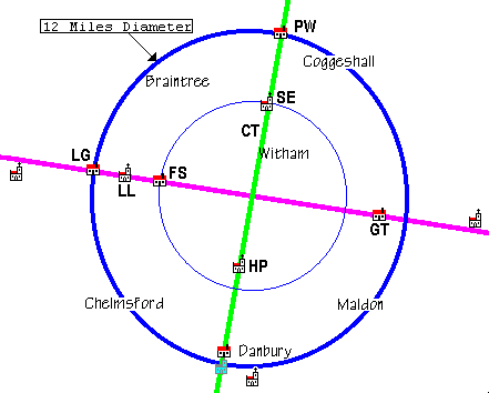
THE AMAZING STRAIGHT LINE
By looking at a map of Essex you can draw a straight line (shown in purple on the diagram) through the following three country pubs:
     The Compasses              Littley Green (LG)   TL 6688 1723
     The Square and Compasses   Fuller Street (FS)   TL 7473 1605
     The Compasses              Gt.Totham     (GT)   TL 8682 1309
Also on this line is a church:
St John the evangelist Little Leighs(LL) TL 7188 1675
Taking a regression line (a mathematical best-fit) through these gives errors off the line of:
     Littley Green    5m
     Little Leighs    6.6m
     Fuller Street    3.3m
     Great Totham     0.9m
These errors are the worst case[calculated by computer not pencil and ruler] (depending
on whether you include the church as one of the points used to compute the regressions
line). Since the resolution of the map references taken from 1:10000 is 10m we might
as well say the straightness of the line is perfect. This line is over 18km long.
The line points to 106 degrees (true) looking ESE.
EXTENDING THE LINE
If the line is extended westwards another kilometre we get to the Ridley brewery at TL 688
175. If the line is extended eastwards 6km the line passes 100m south of St Nicholas church,
at Tolleshunt Darcy and directly through the adjacent moated house.
SQUARE AND CIRCLE
Now drop a perpendicular (green) to the baseline from:
The Compasses Pattiswick (PW) TL 8206 2470
This forms an intersection in the middle of nowhere at TL 7965 1484. (Roughly 600m
SW of Powers Hall Farm.)
The distance from the intersection to Pattiswick is 10.145km which is only 89m more than
the distance to Littley Green being an error of less than one per cent.
Twice the distance from the intersection to Fuller street is 10.132km, an error of less
than 1 in 600 if compared with Pattiswick or less than 1 percent difference if compared
with Littley Green.
Suppose we extend the perpendicular south of the base line. 3 and a bit km south (exactly 2 miles)
is Hatfield Peverel church bang on the line.
Continuation of this line to just within the 10km radius brings us to the Bell Inn at
Danbury. If we plot the exact radius we end at a point just inside Danbury Park currently
with no features on it.
There is no question of a simple line of sight being established along the length of the
base line. Many of the segments definitely aren't straight sighting.
The completed figure can be visualised as a circle 10 miles in diameter in the centre of the
county of Essex, with a roughly east-west base line of astonishing accuracy and a roughly
north-south perpendicular.
>Home page> |
Introduction |
Geometrical facts |
Key places |
Speculations
1b About key places
- Littley Green
- Originally "Little Lee Green" where "Lee" is probably related to the other
various spellings of Leighs/Leez.
- "Compasses" The furthest I can trace the name back to is 1882. However George
Dalby the landlord was a beer seller in Littley Green for 20 years prior to this. The
building itself was built in the 1880's.
>Drop in for a nice pint straight from the barrel>
- Little Leighs
- Church St John the Evangelist. This is (at least) Norman in origin. Inside is a
wooden effigy in religious vestments of an unknown person. There are two tombstones in
the churchyard supposedly of crusaders with a cross pattée and 'a reversed omega'.
- Cole hill
- Chapel about 600m north of the church at Great Leighs. This only appears on the
6" 1st Ed Ordnance Survey (about 1875) but is pretty close to the line. (Difficult
to measure, but I estimate within 25m) This was designated as "non-secretarian".
In 1862, according to the Post Office Directory, "An independent chapel has been erected
at the sole expense of Joseph Tritton Esq. of Norwood Surrey." This might refer to this
building or it might be a replacement for it, the replacement being nearer the
village. Today there is a small plot of flat ground in the right place that could
mark the site.
- Fuller Street
- "Square and Compasses" There is no reference to this before 1926 in the Post
Office Directory. There are no other written records although I'm certain beer was sold
here in the last century, probably very similar to Littley Green. In 1823 there were 2
beerhouses shown in Whites Essex guide. (In a hamlet of a dozen houses!) The building is at
least 200 years old and possibly much older. >Drop in for a nice pint
straight from the barrel>
- Intersection
- If you've seen the middle of a field that has been a field for 3 (and probably many
more) centuries then you'll know that the only fitting description is 'empty'. There
are absolutely no landmarks. A metal detector survey just before the present crop was
planted drew a blank, and local knowledge is also silent.
- Great Totham
- "Compasses" References in parish registers mention this pub in 1758 and the
landlord tells me that someone has traced it back to 1640.
- Eastern extension
- Tolleshunt D'arcy The hall at D'arcy is ancient although remarkably little
history is known about it. The present building goes back to perhaps 1450. The dovecote
through which the line goes is supposed to be Tudor. So far there doesn't appear to be
any significance here. There is a longshot that the dovecote originally served another
purpose, but no evidence for this possibility.
- Northern arm
- Pattiswick "Compasses". Sometime between 1780 and 1781 the name of this pub
was changed from the "Carpenters arms" to "Compasses". The landlord remained the
same, Stephen Bridge. The main feature of the coat of arms of the Carpenters Company
is three compasses.
- Southern arm
- Hatfield peverel church A 19th Century Methodist church. This church is the
only one in the centre of the village. The anglican church is three quarters of a mile
away from the centre and is associated with a priory.
Danbury "Bell" This goes back to at least 1758.
>Home page> |
Introduction |
Geometrical facts |
Key places |
Speculations
2 Speculations
TRAVERSING THE BASE LINE
- Western extension - Black Chapel.
- This is a church sized chapel of ease, the history of which I have not yet
discovered. I assume that the Black refers to the Black
friars. This chapel is in the middle of nowhere but on a
main road so I'd guess that it was associated with a religious
order and not intended to be a parish church. Bearing
in mind the accuracy of the base line this appears to be well
off the line at 150m too far south. My conclusion is
that the history of this place needs investigating but is not
really evidence for the existence of the line.
- Western extension - Brewery
- Naturally, as a drinker, my first thought was that the line
pointed the thirsty to the source of the truly excellent
ales brewed by Mr. Ridley. What could be more satisfying to
the Essex drinker than this solution? As well as the
brewery, at Hertford End, both the Littley Green Compasses and
the Fuller Street Square and Compasses are owned by
Ridleys. At present the earliest known date for these houses
being in Ridleys hands is not known. Neither is the
date of their naming nor the date of their construction.
Behind the brewery (off the line) is a field marked on the
OS 1st Ed as Chapel field. I wonder how it acquired that name?
There is also the remote possibility that Bishop
Ridley (burnt at the stake) had some part to play in the mystery.
- St John the Evangelist - Little Leighs
- One of the 'two' Saints (the other being St John the Baptist) which are associated with
templars and present day masonry. The wooden effigy is regarded
as rather unique but nothing much is known about it.
The two crusader tombs have two interesting features. Firstly
the use of the cross pattée which has perhaps
more than just templar connections. Secondly the inscribed
"reversed omega" appears to be highly unusual. So far I have seen neither the tombs or a picture.
ABOUT THE PERPENDICULAR
The perpendicular passes about half a mile to the east of
Cressing Temple. It passes close to the present
Faulkbourne hall and possibly through the site of the previous
hall. (In local mythology Faulkbourne hall has odd
connections - see below.)
The intersection is in a field with no signs of anything being
there going back to 1777. The adjacent field maps
show arable pasture as the dominant land use very much the same
as today. There used to be (demolished in 1950s) a
couple of cottages near (150m) the intersection point called
"Halfway Cottages".
EXTENDING THE PERPENDICULAR
Suppose we draw a 10km (ie the radius of Pattiswick/Littley
Green) circle centred on the intersection point and then
extend the perpendicular to the south to meet it. We get to
TL 7725 0503 (North-South error of about 80m depending
on how you want to calculate the radius.) This point is now,
and for the last 400 years at least, in Danbury Park.
Once again, there is nothing here.
Danbury is associated with Crusaders. I'd go further and say
templars. The church is dedicated to St John the
Baptist - the patron saint of the templars. The Saint-Clere
(Sinclair) family were associated with Danbury and there
is evidence to suggest that there are Saint-Clere knights
buried in the church. (The Sinclairs were/are mixed up in
templar/masonic activities.)
It appears that there were two churches in Danbury until 1440.
No record remains of where the lost one was or why
Lord D'arcy decided to merge the two. Presumably what with the
drop in population and inflation caused by the black
death 90 years previously and a lack of income there was
neither the need nor the cash for two churches in
Danbury.
The line passes through the "Bell" public house. This has a
private cupboard behind the bar with religious relics
and is supposed to be on the site of a monastery. Why is is
called the Bell? Surely because it is next to the church
- but there is no church nearby! My theory about the "Bell"
is that it used to be next to the church that was
'merged' in 1440. The 1440 date is the date of the legal
merging which may well have been formalising an existing
situation. For some reason it was thought necessary to
preserve the memory of the church in the cupboard behind the
bar. If this was the case then it may indicate the church had
some particular significance. In any event the
'missing church' would be certainly on the perpendicular and
only about 200m short (2%) of the radius.
MASONS AND TEMPLARS
I assume that the connection between Compasses and Square as
Masonic symbols is understood.
The Knights Templars were warrior monks. The order became
wealthy and powerful. It was well disciplined, offered
security services from safe deposit to international credit
transfer in the 12th century. One of their headquarters
was in Essex at Cressing Temple near Witham. There are plenty
of other places in Essex with Templar connections.
For various reasons in 1307 the Templars were brutally and
horribly suppressed in France on orders of the Pope and
the King. Hardly any escaped. In England the Pope's command
was acted on after three months and very half-
heartedly. Only a very few Templars were caught the others
just vanished. It is therefore assumed that they 'went
underground'. If you want the full story and reasoning why
masons were not a guild of craftsmen but a brotherhood of
fugitives then read Robinson's book "Born in blood". In 1717
the Masons broke cover, but until then, in an age when
non-conformism meant burning at the stake, lives really did
depend on absolute trust, secrecy and safe houses for men
on the run.
Danbury and nearby Bicnacre has been associated with the
Templars and supposedly has carvings and tombs of crusaders
in the church. In the Peasants revolt of 1381 (in which the
organising hands of a secret society have been long
suspected) there were battles in the vicinity. Does this point
to a centre of activity at Danbury after the
suppression?
FACTS FROM THE RECORDS SUPPORT THIS THEORY
In 1381 John Spicer of Chelmsford (or possibly Maldon) was a
trader in spices. In those days spices were like
diamonds would be today, so a trader would not be any old
tinker. He'd need capital, credit guarantees, secure
storage and transport, international communications and would
be dealing with the rich not the poor. In which case,
what is a person like this doing stirring up revolt in Essex and
Hertfordshire and taking a special interest in
sacking property of the Hospitallers. (The Hospitalers appear
to have been particularly targeted in the Peasants
revolt. Cressing Temple is one example of ex-templar property
being destroyed.)
The intersection
The central point of the circle, the intersection is in the
middle of nowhere at TL 796 148 between Witham and Terling.
One would expect this to be an important point in the
geometry. Today there is nothing on the a plateau
overlooking Witham.
Tunnels everywhere in folk history!
In Witham, the Church at Chipping Hill (St Nicholas TL 817 154)
has always been associated (in folklore at least)
with the Templars and Faulkbourne hall (Pronounced 'Fourbun'
TL 803 165). Some people claim that there is a secret
tunnel (which would be 1 mile long and go under the river!)
from Faulkbourne to the church. However there are
slightly more believable reports of a tunnel under the
graveyard to a local manor house. I used to think all this
talk of tunnels was just romancing, but perhaps the shorter is
worth investigating further if there really was a need
for literally 'being underground'. Faulkbourne Hall was owned
by the first Master of the Braintree social (masonic)
lodge in the 18th century.
Pub names
In the 19th century it was normal for clubs and societies to
be associated with pubs. There might be a connection
here. We know for example the the Cricketers at Danbury was
a masonic meeting place and in 1874 is run by the same
person who a couple of years earlier was running the Compasses
at Bicnacre. In 1780 there was the "Trowel and
Hammer" in Moulsham Street, Chelmsford, and later (possibly the
same place) a "Masons Arms" in the same street.
SOME OTHER PIECES OF INFORMATION
There was a "Three compasses" at Bicnacre within spitting
distance of the Priory of St John (itself about 3km SE of
the 'missing church') until 1878. There is evidence for this
going back to at least 1770.
Similarly there was (from before 1769 to present day) the
"Three compasses" at West Hanningfield. I can't find any
connection between these except that the priory of St John lay
directly between them. Also I can't find any
geometrical connection between these pubs and the main
geometrical figure. I can find no geometrical link with the
Compasses in Broomfield road Chelmsford that is first recorded
in 1878.
In 1772 there is fleeting evidence for a Compasses pub at Fryerning.
I have not been able to untangle which pub was which in Danbury and
Bicnacre. There might have been just the one with Bicnacre being lumped in
to Danbury. This needs detailed analysis of the records and local research.
There is another Compass pub line in Suffolk although only one of them remains open.
It is longer but not as precise (120yds error in 20 miles) and there is an curious geometrical link with this one.
CONCLUSION
I find the whole aspect of lining things up on maps very odd.
While the pubs all go back probably 200 years in some
form or another and some perhaps 400, I can't really see them
being organised in this geometrical fashion in the 14th
century. In truth it is difficult to think of them being
ORGANISED at all and we might still be in the land of
strange coincidence.
All snippets of information, local history, myths
and references to bunches of Compasses and Carpenters Arms pubs
anywhere in the country would be most welcome. I have a lot of other
odd data but so far nothing more than suggestions of patterns and
vague theories.
Reference to 'underground' templars as foundation of Masons:
BORN IN BLOOD by JOHN J ROBINSON ISBN 009 922861 0
Author: Peter Fox
Address: 2 Tees Close,Witham,Essex CM8 1LG
Telephone: 01 376 517 206
Copyright: Peter Fox
Issue:www-3 March 1997
E-mail:
 ©
©