South West of Ipswich

Exploring the Ipswich, Manningtree, Sudbury triangle

Traditional pubs are struggling in the country. Gentrification and suburbanisation of villages doesn't build communities. So let us celebrate and support the ones that are left.

There are three sections to this web page

  1. General introduction
  2. Pub details
  3. Route details Stick the bits together to suit your own whims.

Back to rides index

General introduction

Look at the map eg. OS Landranger 155 and locate the small town of Hadleigh. To the South and East is a plateau at about 50m above sea level. The Brett valley runs south. To the west is more ‘high' (around 60m) ground with occasional declivities. Your map may show the course of the old railway line running SE from Hadleigh whuch is now an excellent cycle route! There are plenty of possibilities although it should be said that this isn't the most interesting and beautiful part of the world. On the otherhand you're not going to be bothered by too much traffic. Some of the lanes are single track.

Click on the routes shown in green for details.

Back to rides index

Pub details

Cock Royal Oak Queens Head Queens Head White Horse
Brent Eleigh East End, East Bergholt Great Wenham Lower Layham Edwardstone
TL 941 478 TM 099 352 TM 072 386 TM 029 402 TL 951 429
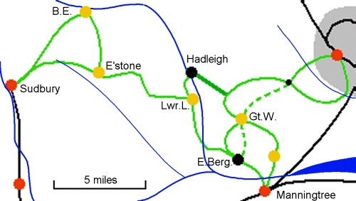
Sudbury 8
Edwardstone 4
Manningtree 3
Gt.Wenham 4
Ipswich 10.5
Manningtree 7.5
Hadleigh 4
Ipswich 13
Manningtree 9
Hadleigh 2
Edwardstone 8
Sudbury 7
Lwr.Layham 8
Brent Eleigh 4
Mon-Sat: 12-3;6-11
Sun: 12-3; 7-10:30
? Mon-Sat: 12-2:30; 6:30-11
Sun: 12-2:30; 7-10:30
Mon-Sat: 12-3; 7-11

(Closed Tue lunchtime)
Sun: 12-3; 7-10:30
Mon,Tue,Thu: 6:30-11
Wed,Fri,Sat: 12-2;6:30-11
Sun 12-3;7-10:30
No food ? Very nice curries (and plain food)
Tue-Sun: 12-2; Tue-Sat:7-9
Food ??
More on another page Appears to be a thriving 'local' Bar billiards
Beer garden
3 Real ales(Adnams+GK)
Real locally made cider
GK 3-4 Real ales(GK+others)
Cask breather
3-4 various real ales(Swan necks) 4 various real ales. Normally a mild.
Back to rides index

Route descriptions

There are many pages of instructions here which I've tried to arrange so you have lots of options and let you join them together.

Overview

Here is a very brief synopsis of some expeditions.

Escaping SW from Ipswich to Washbrook.

Ipswich to Washbrook

My route Nigel Cliffe's local knowledge
  • Right out of station. Complicated but use common sense.
  • (100yds) Fork first right into Whilloughby Road.
  • At T turn left (down)...
  • ...(100yds) then right into Rectory Road.
  • Over brow of hill is an X-roads. Turn right (up) Station St.
  • First left (100yds) into Belstead Avenue. (Signposted Maidenhall)
  • First left (100yds) down into Maidenhall approach.
  • Just after right bend by the church, Left into Halifax Rd.
  • At sharp ight turn go straight on (as if you were heading straight for the Orwell bridge) down the lane between playing fields and allotments.
  • When you reach the railway turn right down track. This isn't the prettiest part of Ipswich but brings you to the entrance to Bourne Park.
  • Cycle straight ahead through the park.Cycling permitted. The official cycle map says not but it is.
  • At the park exit turn left into Stoke Park drive. Note the cycle lanes that are too narrow and stop at the pinch points. Yuk! For safety: Cycle well out and even more so at the traffic islands.
  • Following the road for a 3/4 mile or so brings you to a recent housing estate. This appears to be riddled with cycle tracks but I couldn't bring myself to trust them. Up hill.
  • Just over brow of hill take the left turn, Grove Hill, signposted Belstead. (Don't miss it!)
  • Under A14. After a ½ mile of uphill slog turn right just as you come to the end of Belstead village. (Signposted Copdock)
  • Carry on past the church, over the A12, past another church...
  • At the dual carriageway turn left (up) then immediately right into Elm lane. (Signposted Chattisham).
    When crossing take a good look behind as although there is little traffic it can come fast over the brow of the hill.
  • 1/4 along here you arrive at the staggered junction "Top of Washbrook Hill".
    • North east : Washbrook
    • South West : Great Wenham
    • South East : Belstead
    • North West : Chattisham
  • Route 1 Not suited to those who dislike traffic, and I'd be reluctant to shepherd children along significant parts of this route. Fine for anyone used to urban cycling
    • Right from station to traffic lights, straight on, to next lights where dismount and cross roads, turning right (signs and island layout prevent a right turn on the road).
    • Cycle out of town along Wherstead Road (optional cycle route on old line of Wherstead Road is signed, though only really efficient when heading into town).
    • At strange "dog-bone" roundabout (entrance to port on left),
      you have the option to turn right beside garden centre on path (cycle permitted) through park to pick up the route described in the left column.
      or go left at "second" roundabout (signed Shotley),...
    • then immediately right climbs up hill to ski-centre (very quite road for the climb).
    • At top emerge through gate onto main road to Manningtree near interchange with A14 (extreme care!). Cross A14.
    • Two sub-options
      • Proceed on main road until turn.
      • Right turn to Belstead (cross roads).
      • Follow to Belstead village. After sharp right bend, take left to Copdock and rejoin route shown in left column
      • take first left,
      • follow road, make sharp right turn (by entrance to electric company offices).
      • Then at sharp left bend, proceed straight on along farm track (a ROW, hard concrete wide track).
      • At farm buildings turn right.
      • At cross roads (take care) cross the Manningtree road and pickup the sub-route above.
  • Route 2
    • Left from station...
    • Proceed along Ranlegh Road, straight at first traffic lights, cross minor level crossing.
    • Two alternatives at the traffic lights where London Road meets Ranlegh Road.
      • Straight over traffic lights to Hadleigh Road.
      • Along Hadleigh Road, leaving town.
      • At T-junction, right, then over A14.
      • At roundabout choose route appropriate for chosen pub. Left for Copdock etc.
      • Left up London Road hill (also called Crane Hill). Shared use cycle path on LHS.
      • Cross Robin Drive (traffic light controlled T-junction) and use housing road parallel to main dual carriageway.
      • At end of housing road (Volvo garage), right to lights. (Extreme care!),
      • Cross main road heading for hotel, then mount pavement on RHS (shared use). Follow pavement adjacent to dual carriageway,
      • It leaves main road and dips down past Park and Ride. NB Follow cycling signs/path/red tarmac
      • Under A14 and emerges on end of old line of A12 at Washbrook.
      • Through gates then left of dual carriage way for 100yds
      • Right at bottom of hill
      • Left into Washbrook
      • At pub in village take right forks.
      • This lane brings you up to the 'top of Washbrook hill'

You can use the pavement cycle lane all along the north side of London Road. Eventually this diverges and dives under the A14 by the park and ride. I suggest this is better as a return route though.
Shortest most boring route to Great Wenham
Preferred route to Great Wenham and Hadleigh and all points west
Going back taking advantage of hills

Return from "Top of Washbrook Hill" to Ipswich

A different route takes advantage of the good downhill bits

Washbrook to Gt. Wenham - Short and boring route

4 miles

Washbrook to Rail trail then Gt. Wenham

This is a route with much more potential. (6 miles Washbrook to Gt. Wenham)
The old railway track is well worth exploring if only to test it out for future reference. If you can negotiate the first half mile then the rest will be easy.

It is 2.5 fairly level and traffic-free miles to Hadleigh. For our purposes Lower Layham is less than 2 miles from the Hadleigh end and Gt. Wenham is 2 miles from the country end.

This is worth going to see just to appreciate how useful and pleasant old railway lines can be if properly looked after. It appears to be passable at all times of the year.

I wouldn't cycle along it at night with a single headlamp because of all sorts of small but potentially serious obstacles. However during the day it is a high-speed traffic free link which smooths out the hills very nicely.

Highly recommended - The best of its kind I have found in East Anglia.

Rail trail to Gt.Wenham


Gt. Wenham to Manningtree via East Bergholt - 7.5 miles

Alternative route. 9.5 miles, nicer, via Royal Oak
If you're a tough-old-bird and don't mind lifting your bike over the central barriers on the A12 then do what I did and take the direct route to East Bergholt saving about a mile.
  • Right out of the pub
  • Left at T-junction
  • 1/3rd mile turn right and pass church.
  • This brings you out on the A12. Big problem. No official way across! You could cycle 3/4 mile along the path on this side. Or you can lift your bike over the central barriers and carry on down the lane the other side of the road. (Staggered slightly up hill) this brings you into East Bergholt.
  • First right then right at tee
  • Left at pub takes you into the village centre.
East Bergholt Reverse direction instructions

Gt. Wenham to Manningtree via Capel St. Mary and East End - 9.5 miles

Roundabout lanes via the Oak at East End. This adds three or four miles but if you're not at the limit of your endurance is a bit more interesting. Royal Oak at East End

Manningtree to Lower Layham - 8.5 miles

East Bergholt

Lower Layham to Hadleigh then ...

This is just two miles.

The details of navigating through Hadleigh have yet to be determined. (If you've got this far you should invest in Landranger 155.)

One possible trip is Manningtree - Lower Layham - Hadleigh - Rail Trail - Ipswich or back to Manningtree


Lower Layham to Edwardstone


Edwardstone to Brent Eleigh - 4 easy miles


Brent Eleigh to Sudbury

This is covered in detail on another page.

Edwardstone to Sudbury - Lots of ups and downs - 7 miles

Thanks to Nigel Cliffe for local knowledge. Nigel also says:

Personally, I think starting from Manningtree is a better option for many routes - the station isn't in the middle of a big town. From Manningtree one can cross over to Brantham. At Brantham, either left to East Bergholt, or straight on towards Ipswich. One can avoid climbing Brantham hill in the main traffic, either via bridleway to west of Brantham, heading towards East End (rough, but rideable in dry conditions on 28mm smooth tyred tourer), or by snaking up through the village streets (sorry either do it by map, judgement, or GPS!).

The Shotley peninsula is worth exploring, I recommend the southern road from Stutton to Shotley rather than the northern one from Ipswich (too busy). It can be linked to an interesting trip by using the ferry to Harwich (check its running by phone before committing !).

Back to rides index